
Issue
Humboldt Bay and the Eel River Estuary make up one of California’s largest estuarine systems, supporting the greatest number of wetland wildlife species between San Francisco Bay and the Columbia River. The area’s rich natural resources are threatened by habitat fragmentation, degradation, and loss. The 2006 “Northern California Coastal Conservation Needs Assessment” (conducted by the California Coastal Conservancy and its partners) highlighted the need for coastal and marine spatial data useful for resource protection efforts.
Process
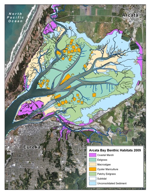
To address the needs identified in the assessment, many partners joined together and worked through the Humboldt Bay Ecosystem-based Management Program to describe and evaluate intertidal and subtidal habitats. Their work was aided by the acquisition of high-resolution multispectral imagery in 2009, which was used to generate benthic habitat data.
Impact
This ecological health data has yielded many positive results: more accurate characterizations of the region; enhanced ability to research and monitor habitat issues; and the ability to better inform conservation and resource usage decisions.
The data being was used to evaluate potential expansion of oyster mariculture activities, and was also used in a project designed to control invasive species, monitor rare species, and determine habitat boundaries. Another project used the data to locate existing channels and other geographic features as part of a restoration effort.
Contributing Partners
- California Coastal Conservancy
- U.S. Fish and Wildlife Service Coastal Program and Humboldt Bay National Wildlife Refuge
- Humboldt Bay Harbor, Recreation and Conservation District
- Humboldt Bay Initiative
- Humboldt State University
- The Nature Conservancy
- NOAA National Weather Service
- NOAA Office for Coastal Management
- Photo Science
- California Sea Grant