Issue
Tropical urban forests provide a wide range of environmental and socioeconomic services, including protection from catastrophic storms, sea level rise, and coastal erosion, and absorption of stormwater runoff that can otherwise impact coral reefs and nearshore marine ecosystems. The State of Hawaii undertook to spatially define priority urban forests as a component of the 2010 Hawaii Statewide Assessment of Forest Conditions and Resource Strategy. However, a data layer did not exist to represent these areas in Hawaii.
Process
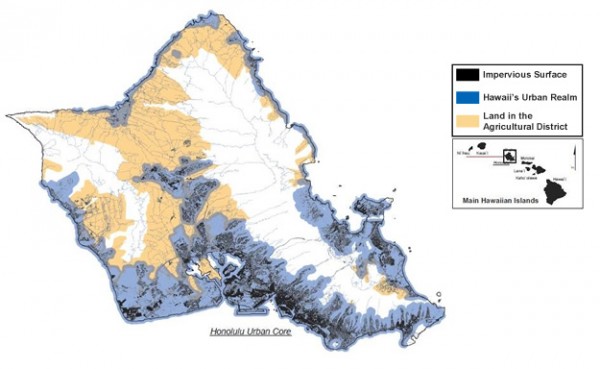
Hawaii’s Kaulunani Urban and Community Forestry Program (UCF), funded by the U.S. Forest Service and the state’s Division of Forestry and Wildlife, organized the Tropical Urban and Community Forestry Summit in 2009 to share information on urban forestry issues and priorities for the Pacific. The UCF program brought partners and stakeholders together during the conference to create a process to develop a spatial data layer representing Hawaii’s urban areas. Existing data layers and unique local considerations were discussed to help define the urban areas within the state. The resulting “Urban Realm” data layer was assembled using the impervious surfaces class from NOAA’s Coastal Change Analysis Program (C-CAP) high-resolution land cover data. This specific class was used to represent existing urbanized areas and was merged with other existing data to best represent the areas where people live, work, and play.
Impact
C-CAP land cover data were an integral part of mapping Hawaii’s urban realm. The high-resolution data captured the detail of the urban landscape across the state. With the urban realm mapped, the state was better able to identify urban forests and develop a set of long-term management activities and environmental literacy initiatives. These activities will ultimately enhance the health of coastal ecosystems and the resilience of coastal communities.