Issue
Land-based sources of pollution, including sediment, are one of the primary threats to coral reefs in many island environments. Research suggests that successful management of fringing reefs adjacent to volcanic islands may not be possible without proper land use management in contributing watersheds. Effectively analyzing land-based threats and prioritizing actions to combat them not only requires traditional ecological knowledge, but also accurate, up-to-date maps—which were lacking in Saipan, Commonwealth of the Northern Mariana Islands (CNMI).
Process
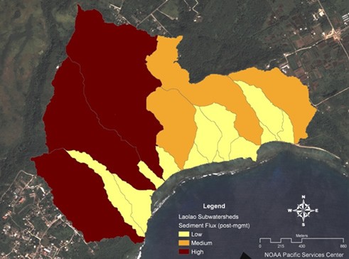
Saipan’s Laolao Bay watershed is covered by a mix of non-native forests, grasslands, plantations, and urban areas, with several known sediment sources. Managers used NOAA’s Nonpoint-Source Pollution and Erosion Comparison Tool (N-SPECT) to develop graphical interpretations of these sediment source areas and compare the relative changes in sediment flux under different scenarios, such as replanting trees and paving roads. They used the NOAA Habitat Priority Planner, with additional techniques and tools, to develop strategies for coral reef protection. Elevation data derived from lidar and land cover data developed from satellite imagery provided base map information for the erosion analysis of the watershed. These data sources were combined to meet the community’s interests and priorities.
Impact
The resulting maps—derived from accurate, modern technology—proved extremely useful for Laolao Bay’s watershed management planning. Fusing traditional ecological knowledge with geospatial data created relevant information to assess current problems and inform future management and conservation efforts of the region’s coral reefs.