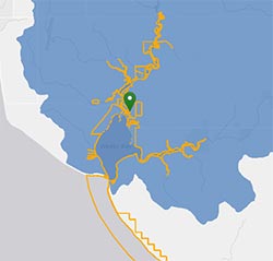
Reserve Detail Map
Click the markers on the map above to see detailed information about each Reserve.
Thirty coastal sites make up the National Estuarine Research Reserve System. Explore your local reserve to learn about weather, water data, and so much more. Use the reserve map below or contact an Education Coordinator.
Click the markers on the map above to see detailed information about each Reserve.
A biogeographic region is a geographic area with similar dominant plants, animals and prevailing climate. Reserves represent different biogeographic regions of the United States.
Back to Map
National Estuarine Reserve System
Connecticut41.27°N 72.23°W
2022
52,160 acres (211 km2)
Coastal Plain
Virginian
| Weather: | High | Low | Ave. |
|---|---|---|---|
| Air temp (°C) |
| Water: | High | Low | Ave. |
|---|---|---|---|
| Water temp (°C) | |||
| Dissolved Oxygen (%) | |||
| pH | |||
| Salinity (ppt) | |||
| Turbidity (NTU) |
Back to Map
National Estuarine Reserve System
Maine43.34°N 70.54°W
1986
2,250 acres (7 km2)
Bar-built
Acadian
3.4 meters
| Weather: Laudholm Farm | High | Low | Ave. |
|---|---|---|---|
| Air temp (°C) | 36.6 | -25.6 | 8.2 |
| Water: Little River Mouth | High | Low | Ave. |
|---|---|---|---|
| Water temp (°C) | 29.5 | -1.0 | 12.5 |
| Dissolved Oxygen (%) | 140.8 | 10.1 | 97.0 |
| pH | 12.9 | 2.1 | 7.6 |
| Salinity (ppt) | 34.7 | 0.1 | 17.4 |
| Turbidity (NTU) | 976 | 1 | 7 |
Back to Map
National Estuarine Reserve System
New Hampshire43.07°N 70.87°W
1989
10,235 acres (21 km2)
Coastal Plain
Acadian
2.5 meters
| Weather: Greenland | High | Low | Ave. |
|---|---|---|---|
| Air temp (°C) | 35.7 | -26.8 | 7.9 |
| Water: Great Bay | High | Low | Ave. |
|---|---|---|---|
| Water temp (°C) | 27.2 | -2.3 | 15.4 |
| Dissolved Oxygen (%) | 170.2 | 69.9 | 99.7 |
| pH | 9.6 | 3.3 | 7.8 |
| Salinity (ppt) | 35.2 | 0.1 | 22.5 |
| Turbidity (NTU) | 999 | 1 | 19 |
Back to Map
National Estuarine Reserve System
Massachusetts41.58°N 70.53°W
1988
2,780 acres (9 km2)
Bar-built/Coastal Plain
Virginian
0.6 meters
| Weather: Carriage House | High | Low | Ave. |
|---|---|---|---|
| Air temp (°C) | 34.6 | -21.0 | 10.6 |
| Water: Childs River | High | Low | Ave. |
|---|---|---|---|
| Water temp (°C) | 29.9 | -1.3 | 13.9 |
| Dissolved Oxygen (%) | 321.5 | 0.1 | 90.9 |
| pH | 9.7 | 6.1 | 8.0 |
| Salinity (ppt) | 31.3 | 0.1 | 26.9 |
| Turbidity (NTU) | 993 | 1 | 4 |
Back to Map
National Estuarine Reserve System
Rhode Island41.64°N 71.34°W
1980
4,259 acres (17 km2)
Coastal Plain
Virginian
N/A
| Weather: Potters Cove | High | Low | Ave. |
|---|---|---|---|
| Air temp (°C) | 36.6 | -21.2 | 10.2 |
| Water: Potters Cove | High | Low | Ave. |
|---|---|---|---|
| Water temp (°C) | 44.8 | -4.9 | 12.2 |
| Dissolved Oxygen (%) | 209.5 | 5.2 | 95.8 |
| pH | 9.5 | 2.1 | 7.9 |
| Salinity (ppt) | 39.7 | 0.1 | 28.3 |
| Turbidity (NTU) | 999 | 1 | 7 |
Back to Map
National Estuarine Reserve System
New York42.02°N 73.91°W
1982
4,838 acres (20 km2)
Coastal Plain/Fjord
Virginian
1.2 meters
| Weather: Field Station | High | Low | Ave. |
|---|---|---|---|
| Air temp (°C) | 49.9 | -39.5 | 10.0 |
| Water: Saw Kill | High | Low | Ave. |
|---|---|---|---|
| Water temp (°C) | 28.4 | -0.1 | 14.9 |
| Dissolved Oxygen (%) | 128.3 | 80.9 | 99.5 |
| pH | 9.4 | 3.9 | 8.2 |
| Salinity (ppt) | 0.3 | 0.1 | 0.2 |
| Turbidity (NTU) | 987 | 1 | 6 |
Back to Map
National Estuarine Reserve System
New Jersey39.55°N 74.46°W
1998
114,665 acres (461 km2)
Coastal Plain
Virginian
1.0 meters
| Weather: Nacote Creek | High | Low | Ave. |
|---|---|---|---|
| Air temp (°C) | 37.4 | -15.9 | 11.5 |
| Water: Chestnut Neck | High | Low | Ave. |
|---|---|---|---|
| Water temp (°C) | 30.9 | -3.0 | 15.1 |
| Dissolved Oxygen (%) | 126.1 | 2.8 | 86.5 |
| pH | 10.0 | 4.4 | 7.4 |
| Salinity (ppt) | 29.7 | 0.1 | 15.0 |
| Turbidity (NTU) | 993 | 1 | 11 |
Back to Map
National Estuarine Reserve System
Delawre39.08°N 75.46°W
1993
4,930 acres (20 km2)
Coastal Plain
Virginian
N/A
| Weather: Saint Jones River | High | Low | Ave. |
|---|---|---|---|
| Air temp (°C) | 37.5 | -16.1 | 13.1 |
| Water: Scotton Landing | High | Low | Ave. |
|---|---|---|---|
| Water temp (°C) | 32.3 | -1.3 | 15.3 |
| Dissolved Oxygen (%) | 173.2 | 0.1 | 67.1 |
| pH | 8.9 | 5.9 | 7.2 |
| Salinity (ppt) | 43.6 | 0.1 | 11.2 |
| Turbidity (NTU) | 999 | 1 | 63 |
Back to Map
National Estuarine Reserve System
Maryland38.78°N 76.71°W
1985, 1990
6,249 acres (20 km2)
Coastal Plain
Virginian
0.6 meters
| Weather: Jug Bay | High | Low | Ave. |
|---|---|---|---|
| Air temp (°C) | 41.6 | -16.7 | 13.7 |
| Water: Railroad | High | Low | Ave. |
|---|---|---|---|
| Water temp (°C) | 33.0 | -0.4 | 15.6 |
| Dissolved Oxygen (%) | 168.2 | 29.7 | 83.3 |
| pH | 9.1 | 4.6 | 7.2 |
| Salinity (ppt) | 2.4 | 0.1 | 0.2 |
| Turbidity (NTU) | 996 | 1 | 24 |
Back to Map
National Estuarine Reserve System
Virginia37.41°N 76.71°W
1991
4,435 acres (18 km2)
Coastal Plain
Virginian
0.9 meters
| Weather: Taskinas Creek | High | Low | Ave. |
|---|---|---|---|
| Air temp (°C) | 42.4 | -12.7 | 15.4 |
| Water: Taskinas Creek | High | Low | Ave. |
|---|---|---|---|
| Water temp (°C) | 36.1 | -3.4 | 17.0 |
| Dissolved Oxygen (%) | 244.9 | 21.1 | 90.2 |
| pH | 9.9 | 2.5 | 7.5 |
| Salinity (ppt) | 22.2 | 0.1 | 10.8 |
| Turbidity (NTU) | 999 | 1 | 67 |
Back to Map
National Estuarine Reserve System
North Carolina34.16°N 77.85°W
1985, 1991
10,000 acres (41 km2)
Bar-built/Coastal Plain
Carolinian
1.2 meters
| Weather: Research Creek | High | Low | Ave. |
|---|---|---|---|
| Air temp (°C) | 38.9 | -8.9 | 17.4 |
| Water: Research Creek | High | Low | Ave. |
|---|---|---|---|
| Water temp (°C) | 37.3 | -1.4 | 19.6 |
| Dissolved Oxygen (%) | 492.8 | 2.0 | 88.6 |
| pH | 10.8 | 2.2 | 8.0 |
| Salinity (ppt) | 44.2 | 0.2 | 28.5 |
| Turbidity (NTU) | 999 | 1 | 30 |
Back to Map
National Estuarine Reserve System
South Carolina33.35°N 79.19°W
1992
12,327 acres (50 km2)
Bar-built/Coastal Plain
Carolinian
1.4 meters
| Weather: Oyster Landing | High | Low | Ave. |
|---|---|---|---|
| Air temp (°C) | 36.7 | -8.8 | 17.8 |
| Water: Oyster Landing | High | Low | Ave. |
|---|---|---|---|
| Water temp (°C) | 37.2 | -0.9 | 20.2 |
| Dissolved Oxygen (%) | 139.9 | 9.7 | 79.1 |
| pH | 9.8 | 3.2 | 7.6 |
| Salinity (ppt) | 39.7 | 0.2 | 32.4 |
| Turbidity (NTU) | 999 | 1 | 14 |
Back to Map
National Estuarine Reserve System
South Carolina32.56°N 80.44°W
1992
134,710 acres (553 km2)
Bar-built
Carolinian
1.9 meters
| Weather: Bennett's Point | High | Low | Ave. |
|---|---|---|---|
| Air temp (°C) | 49.1 | -39.9 | 18.9 |
| Water: Mosquito Creek | High | Low | Ave. |
|---|---|---|---|
| Water temp (°C) | 33.2 | 4.7 | 20.3 |
| Dissolved Oxygen (%) | 127.8 | 2.6 | 73.4 |
| pH | 8.4 | 6.3 | 7.4 |
| Salinity (ppt) | 34.1 | 0.3 | 18.3 |
| Turbidity (NTU) | 999 | 1 | 32 |
Back to Map
National Estuarine Reserve System
Georgia31.42°N 81.30°W
1976
6,110 acres (25 km2)
Bar-built
Carolinian
2.3 meters
| Weather: Marsh Landing | High | Low | Ave. |
|---|---|---|---|
| Air temp (°C) | 38.2 | -14.6 | 19.9 |
| Water: Lower Duplin | High | Low | Ave. |
|---|---|---|---|
| Water temp (°C) | 40.1 | 5.8 | 21.0 |
| Dissolved Oxygen (%) | 136.8 | 0.8 | 79.0 |
| pH | 10.6 | 5.5 | 7.8 |
| Salinity (ppt) | 41.1 | 0.1 | 27.4 |
| Turbidity (NTU) | 998 | 1 | 51 |
Back to Map
National Estuarine Reserve System
Florida29.67°N 81.26°W
1999
55,000 acres (223 km2)
Bar-built
Carolinian
N/A
| Weather: Pellicer Creek | High | Low | Ave. |
|---|---|---|---|
| Air temp (°C) | 39.4 | -5.1 | 20.6 |
| Water: Pellicer Creek | High | Low | Ave. |
|---|---|---|---|
| Water temp (°C) | 35.8 | 3.6 | 23.3 |
| Dissolved Oxygen (%) | 142.5 | 7.2 | 71.1 |
| pH | 9.7 | 2.1 | 7.4 |
| Salinity (ppt) | 47.5 | 0.1 | 17.7 |
| Turbidity (NTU) | 999 | 1 | 16 |
Back to Map
National Estuarine Reserve System
Florida26.03°N 81.73°W
1978
110,000 acres (445 km2)
Bar-built/Coastal Plain
West Indian
N/A
| Weather: Pellicer Creek | High | Low | Ave. |
|---|---|---|---|
| Air temp (°C) | 36.6 | -0.8 | 22.9 |
| Water: Pellicer Creek | High | Low | Ave. |
|---|---|---|---|
| Water temp (°C) | 34.9 | 7.3 | 25.6 |
| Dissolved Oxygen (%) | 161.7 | 8.4 | 83.4 |
| pH | 8.7 | 4.7 | 7.9 |
| Salinity (ppt) | 42.1 | 0.1 | 32.6 |
| Turbidity (NTU) | 996 | 1 | 15 |
Back to Map
National Estuarine Reserve System
Florida29.79°N 84.88°W
1979
246,000 acres (999 km2)
Delta System
Louisianian
0.6 meters
| Weather: East Bay | High | Low | Ave. |
|---|---|---|---|
| Air temp (°C) | 41.1 | -39.9 | 20.1 |
| Water: East Bay Surface | High | Low | Ave. |
|---|---|---|---|
| Water temp (°C) | 34.2 | -1.2 | 22.7 |
| Dissolved Oxygen (%) | 183.9 | 0.1 | 78.3 |
| pH | 10.3 | 4.0 | 7.6 |
| Salinity (ppt) | 34.1 | 0.1 | 9.2 |
| Turbidity (NTU) | 999 | 1 | 16 |
Back to Map
National Estuarine Reserve System
Alabama30.42°N 87.82°W
1986
6,525 acres (35 km2)
Coastal Plain
Louisianian
0.5 meters
| Weather: Safe Harbor | High | Low | Ave. |
|---|---|---|---|
| Air temp (°C) | 38.7 | -8.3 | 18.5 |
| Water: Fish River | High | Low | Ave. |
|---|---|---|---|
| Water temp (°C) | 35.1 | 4.3 | 22.3 |
| Dissolved Oxygen (%) | 199.9 | 0.1 | 79.9 |
| pH | 9.8 | 3.9 | 7.3 |
| Salinity (ppt) | 25.2 | 0.1 | 7.5 |
| Turbidity (NTU) | 999 | 1 | 24 |
Back to Map
National Estuarine Reserve System
Mississippi30.38°N 88.44°W
1999
18,400 acres (73 km2)
Delta System
Louisianian
N/A
| Weather: Crooked Bayou | High | Low | Ave. |
|---|---|---|---|
| Air temp (°C) | 35.8 | -6.7 | 19.7 |
| Water: Bayou Cumbest | High | Low | Ave. |
|---|---|---|---|
| Water temp (°C) | 36.6 | -4.6 | 23.1 |
| Dissolved Oxygen (%) | 215.3 | 5.3 | 79.7 |
| pH | 9.2 | 5.2 | 7.3 |
| Salinity (ppt) | 35.0 | 0.1 | 17.9 |
| Turbidity (NTU) | 993 | 1 | 16 |
Back to Map
National Estuarine Reserve System
Texas28.13°N 97.03°W
2006
185,708 acres (752 km2)
Coastal Plain/Bar-built
Louisianian
N/A
| Weather: Copano Bay East | High | Low | Ave. |
|---|---|---|---|
| Air temp (°C) | 42.7 | -4.2 | 21.5 |
| Water: Copano Bay East | High | Low | Ave. |
|---|---|---|---|
| Water temp (°C) | 44.8 | 4.5 | 23.2 |
| Dissolved Oxygen (%) | 158.6 | 3.1 | 97.7 |
| pH | 8.9 | 4.9 | 8.2 |
| Salinity (ppt) | 42.4 | 0.3 | 20.2 |
| Turbidity (NTU) | 931 | 1 | 25 |
Back to Map
National Estuarine Reserve System
Puerto Rico17.94°N 66.23°W
1981
2,883 acres (11 km2)
Bar-built
West Indian
0.6 meters
| Weather: Jobos Bay Weather | High | Low | Ave. |
|---|---|---|---|
| Air temp (°C) | 36 | 16.2 | 26.2 |
| Water: Station 19 | High | Low | Ave. |
|---|---|---|---|
| Water temp (°C) | 39.1 | 20.0 | 28.5 |
| Dissolved Oxygen (%) | 230.6 | 20.9 | 99.9 |
| pH | 9.1 | 6.2 | 8.0 |
| Salinity (ppt) | 68.8 | 0.1 | 35.3 |
| Turbidity (NTU) | 999 | 1 | 37 |
Back to Map
National Estuarine Reserve System
Ohio41.38°N 82.51°W
1980
571 acres (2 km2)
Coastal Plain
Great Lakes
N/A
| Weather: Old Woman Creek | High | Low | Ave. |
|---|---|---|---|
| Air temp (°C) | 35.1 | -25.5 | 10.2 |
| Water: Lower Estuary | High | Low | Ave. |
|---|---|---|---|
| Water temp (°C) | 34.0 | -3.0 | 16.8 |
| Dissolved Oxygen (%) | 314.0 | 3.7 | 82.4 |
| pH | 9.4 | 4.2 | 7.8 |
| Salinity (ppt) | 0.8 | 0.1 | 0.3 |
| Turbidity (NTU) | 999 | 1 | 63 |
Back to Map
National Estuarine Reserve System
Wisconsin46.69°N 92.17°W
2010
16,697 acres (68 km2)
Bar barrier
Great Lakes
N/A
| Weather: | High | Low | Ave. |
|---|---|---|---|
| Air temp (°C) | No data yet |
| Water: | High | Low | Ave. |
|---|---|---|---|
| Water temp (°C) | No data yet | ||
| Dissolved Oxygen (%) | |||
| pH | |||
| Salinity (ppt) | |||
| Turbidity (NTU) |
Back to Map
National Estuarine Reserve System
California32.57°N 117.13°W
1982
2,513 acres (10 km2)
Bar-built
Californian
N/A
| Weather: Tidal Linkage | High | Low | Ave. |
|---|---|---|---|
| Air temp (°C) | 36.5 | 0.1 | 15.9 |
| Water: Tidal Linkage | High | Low | Ave. |
|---|---|---|---|
| Water temp (°C) | 39.5 | 5.1 | 20.2 |
| Dissolved Oxygen (%) | 499.8 | 0.1 | 91.6 |
| pH | 14.0 | 2.9 | 7.7 |
| Salinity (ppt) | 40.7 | 0.2 | 28.5 |
| Turbidity (NTU) | 999 | 1 | 38 |
Back to Map
National Estuarine Reserve System
California36.82°N 121.74°W
1979
1,400 acres (6 km2)
Coastal Plain/Tectonic
Californian
N/A
| Weather: Caspian Weather Station | High | Low | Ave. |
|---|---|---|---|
| Air temp (°C) | 37.2 | -2.5 | 12.5 |
| Water: South Marsh | High | Low | Ave. |
|---|---|---|---|
| Water temp (°C) | 28.7 | 0.0 | 15.0 |
| Dissolved Oxygen (%) | 444.1 | 0.1 | 82.7 |
| pH | 10.5 | 2.1 | 7.9 |
| Salinity (ppt) | 58.6 | 0.1 | 31.9 |
| Turbidity (NTU) | 996 | 1 | 11 |
Back to Map
National Estuarine Reserve System
California38.19°N 122.03°W
2003
3,710 acres (15 km2)
Tectonic
Californian
N/A
| Weather: Rush Ranch | High | Low | Ave. |
|---|---|---|---|
| Air temp (°C) | 40.0 | -4.4 | 14.3 |
| Water: First Mallard | High | Low | Ave. |
|---|---|---|---|
| Water temp (°C) | 27.2 | 5.7 | 16.1 |
| Dissolved Oxygen (%) | 140.9 | 2.7 | 72.0 |
| pH | 8.3 | 6.8 | 7.6 |
| Salinity (ppt) | 10.3 | 0.3 | 4.5 |
| Turbidity (NTU) | 965 | 1 | 46 |
Back to Map
National Estuarine Reserve System
Oregon43.34°N 124.32°W
1974
4,779 acres (18 km2)
Coastal Plain/Tectonic
Columbian
3.7 meters
| Weather: Charleston Met. Station | High | Low | Ave. |
|---|---|---|---|
| Air temp (°C) | 32.5 | -6.3 | 10.3 |
| Water: Charleston Bridge | High | Low | Ave. |
|---|---|---|---|
| Water temp (°C) | 23.0 | 0.3 | 11.6 |
| Dissolved Oxygen (%) | 173.1 | 19.6 | 95.6 |
| pH | 12.1 | 4.5 | 8.1 |
| Salinity (ppt) | 37.0 | 0.1 | 29.7 |
| Turbidity (NTU) | 999 | 1 | 20 |
Back to Map
National Estuarine Reserve System
Washington48.50°N 122.50°W
1980
13,335 acres (43 km2)
Delta System/Fjord
Columbian
3.7 meters
| Weather: Padilla Bay Farm | High | Low | Ave. |
|---|---|---|---|
| Air temp (°C) | 29.7 | -15.2 | 9.9 |
| Water: Bayview Channel | High | Low | Ave. |
|---|---|---|---|
| Water temp (°C) | 23.5 | -1.5 | 10.5 |
| Dissolved Oxygen (%) | 258.3 | 38.5 | 97.1 |
| pH | 9.3 | 6.1 | 8.0 |
| Salinity (ppt) | 32.2 | 15.4 | 29.0 |
| Turbidity (NTU) | 999 | 1 | 6 |
Back to Map
National Estuarine Reserve System
Alaska59.60°N 151.41°W
1999
365,000 acres (1,477 km2)
Fjord
Fjord
8.7 meters
| Weather: Homer | High | Low | Ave. |
|---|---|---|---|
| Air temp (°C) | 23.6 | -16.2 | 4.5 |
| Water: Homer Dolphin Surface | High | Low | Ave. |
|---|---|---|---|
| Water temp (°C) | 24.5 | -2.3 | 7.8 |
| Dissolved Oxygen (%) | 490.8 | 0.2 | 104.6 |
| pH | 14.0 | 3.3 | 8.1 |
| Salinity (ppt) | 32.8 | 0.1 | 28.6 |
| Turbidity (NTU) | 996 | 1 | 11 |
Back to Map
National Estuarine Reserve System
Hawaii21.44°N 157.81°W
2017
1,385 acres (5.6 km2)
Insular
Insular
| Weather: | High | Low | Ave. |
|---|---|---|---|
| Air temp (°C) |
| Water: | High | Low | Ave. |
|---|---|---|---|
| Water temp (°C) | |||
| Dissolved Oxygen (%) | |||
| pH | |||
| Salinity (ppt) | |||
| Turbidity (NTU) |