Blue Plan Maximizes Coastal Coordination, Minimizes Conflict
The Takeaway: This inventory of the natural resources and uses of the Long Island Sound represents a guide for the future.

Photo credit: Getty Images
The Long Island Sound Blue Plan, a multi-partner effort led by the Connecticut Coastal Management Program, features an interactive map viewer, practitioner’s guide, and other resources to help protect coastal resources and guide offshore development. This inventory of the Sound’s natural resources and uses is helping people across the public-private spectrum plan for wind transmission cables, address ship traffic issues, open public access, avoid site conflicts, inform seagrass conservation, and more.
The Connecticut Coastal Management Program is part of the state’s Department of Energy and Environmental Protection. Long Island Sound is held in public trust by Connecticut and New York State and brings roughly $5.5 billion per year to the region while hosting 120 finfish species and countless bird species, more than eight million residents within its watershed, and up to 50,000 vessels on a summer’s day.
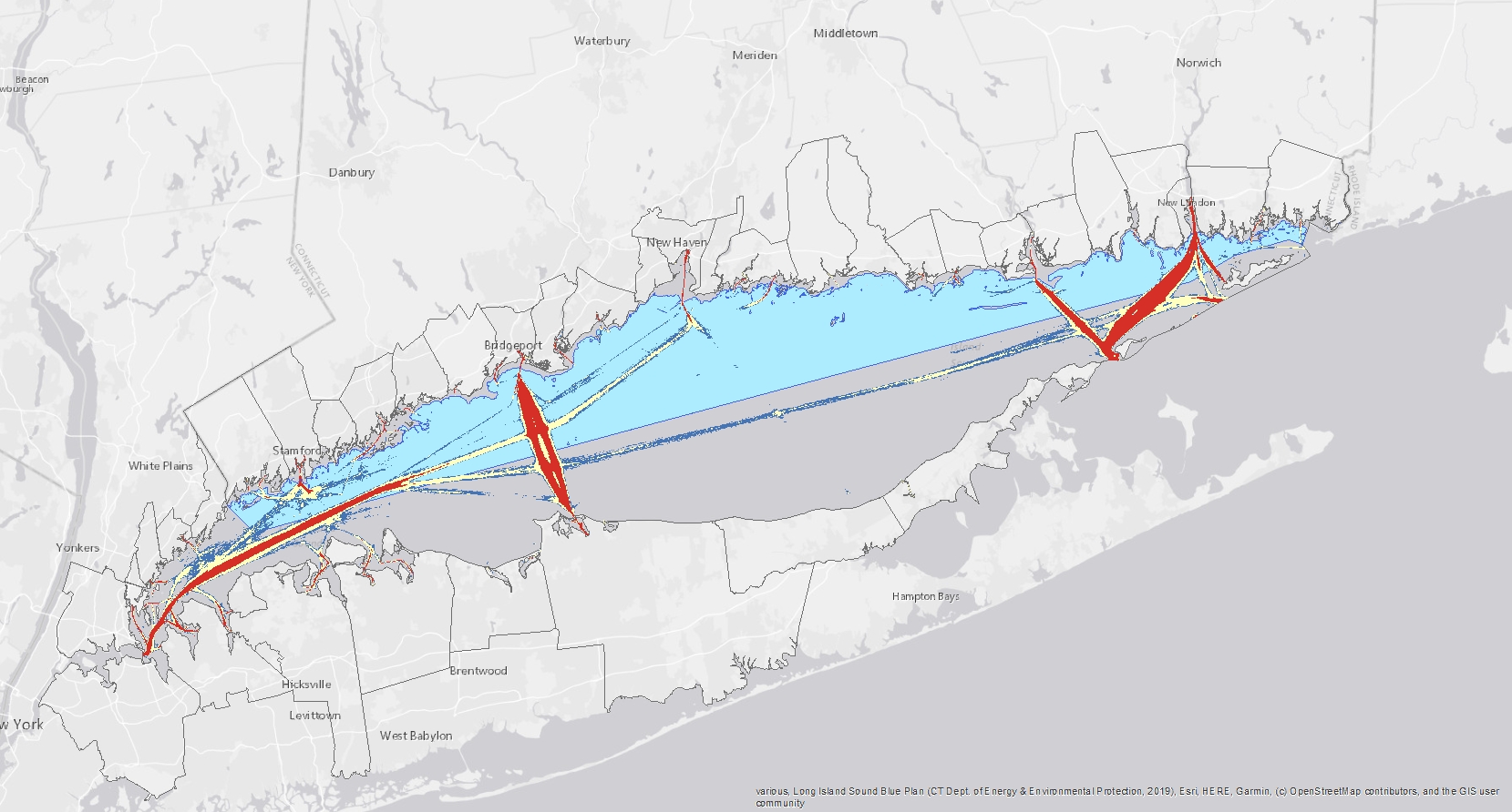
Photo credit: Blue Plan map viewer
The Blue Plan informed the recent designation of the Connecticut National Estuarine Research Reserve. Other Blue Plan uses, current and anticipated, are included below.
- Planning for wind energy transmission cables: The Blue Plan and data viewer are helping offshore wind energy planners and developers assess siting alternatives for potential transmission cables, which would travel from offshore wind areas to land locations in Connecticut and New York.
- Improving waterway planning: In the Connecticut Town of Darien, the map viewer’s features enhance coordination between planners and a local coastal water commission concerning mooring, fishing, water trail, and sailing areas.
- Opening public access possibilities: In the City of Bridgeport, a waterfront advisory board is using Blue Plan maps to consider new public access sites near Pleasure Beach, the Bridgeport Harbor, Yellow Mill Channel, and Pequonnock River.
- Avoiding site conflicts: Aquaculture representatives are using the viewer and natural resources inventory to identify potential conflicts early and collaborate on solutions.
- Increasing agency know-how: The plan’s users include many agencies with jurisdiction in the Sound, including the NOAA National Marine Fisheries Service, U.S. Fish and Wildlife Service, U.S. Coast Guard, and U.S. Environmental Protection Agency.
- Strengthening waterfront connections: The plan can help identify working waterfronts for America’s Marine Highway program, a network of maritime expressways.
- Informing seagrass conservation: Although the Blue Plan is a Connecticut-based plan, the inventory also contains Sound-wide data from New York waters. Partners in New York State have used the map viewer to identify marinas and working waterfronts near Fishers Island that could affect seagrass health. Fishers Island is surrounded by one-quarter of the Sound’s remaining seagrass meadows.
- Providing Connecticut with say-so in federal decision-making: The federal consistency provision of the Coastal Zone Management Act requires that federal actions that have reasonably foreseeable effects on coastal uses and resources be consistent with a state’s enforceable policies. The Blue Plan’s enforceable policies will give Connecticut a voice in federal activities occurring within the Sound.
This project has received funding from the Long Island Sound Study through the Long Island Sound Futures Fund. (2022)
Partners: Blue Plan Advisory Committee, Connecticut Department of Energy and Environmental Protection’s Coastal Management Program, Connecticut Sea Grant, Long Island Sound Futures Fund, State of New York, The Nature Conservancy, University of Connecticut’s Center for Land Use Education and Research
PRINT